Monday 6 February 2012

Water water everywhere

This morning, in Guyana, as well as in frozen Britain, the weather dominates conversation.

Here, an extreme rainy season, attributed to the La Nina phenomenon (no mention of global warming in the local press) predicted to continue throughout the first quarter of 2012, is producing incredible heavy showers -making any outdoor activity virtually impossible- interspersed with light rain, then hot sunny spells. A village near New Amsterdam currently holds the 2012 rainfall record, with 172.6 mm in 24 hours. The average normal monthly rainfall is 60mm/ 2.4 inches.

Georgetown-flooding. Picture- Stabroek News


The people of Guyana are no strangers to flooding and the awful personal, health and economic effects.  In ground floor houses property is spoiled, agricultural crops are ruined, livestock lost and health care officials are warning of the symptoms of water born illnesses, including leptospirosis, and instructing hospitals and clinics to stock up on medications.

Guyana last experience of serious flooding in 2005, (the period during the aftermath of the tragic Boxing Day tsunami in south east Asia) attributed to an extreme weather system, serves as a reminder that Guyana is classified as a nation vulnerable to the effects of global warning, according the the Intergovernmental Panel on Climate Change, the Stern Report and others. Guyana lost 67% of its Gross Domestic Product in 2005, due to loss of agricultural produce, and is still recovering from its aftermath.

Why is Guyana vulnerable?
Guyana's coastal strip where 90% of the population lives is between 1.2m and 2m below sea level (depending on information source). This includes the capital Georgetown, at the mouth of the Demerara River.
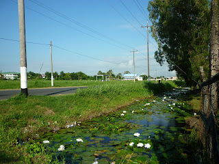
The dams, canals and sluices or kokers, which control the drainage of the low lying land, remain one of the key legacies of Dutch settlement.

Above- a koker.

Built from the second half of the 17th century onwards, with the sweat of African slaves until 1838, and afterwards with poorly paid African and indentured Indian labour, the system provides a network of salt -free canals for drainage, irrigation and transport, generates tracts of usable arable land from former salt marshes and keeps the sea at bay. The canals occupy an eighth of the surface area of the agricultural land and run for a total of 8,000 kms. Sugar was, and remains, the major plantation crop along with rice and bananas.

Maintenance of the system is crucial to Guyana's very existence. Canals should be weeded and cleared of silt and debris 2-3 times per year. Until the mid 1970's work on the sea defences, drainage and irrigation accounted for most of Guyana's capital expenditure. 
Since the economic collapse of the late 70s- 80s, maintenance has been piecemeal or neglected. 

International aid for engineering projects has been welcomed in recent times, but a key challenge made by opposition politicians and ordinary citizens is the lack of policy regarding waste disposal.


Picture- from Kaiteur News-shows officials inspecting a rubbish choked canal.


Picture-Guyana Ministry of Agriculture-canal dredging


This, and the lack of routine dredging and weeding of the canals, strains the drainage and pumping systems to the point of collapse.
It is these factors, plus the estimated rises in sea levels, measured at 6-8 inches in the last century, with a current rate of 12- 14 inches per century, expected to rise to 20 inches plus if rates of global warming continue, all point to a scary future for Guyana.


Picture- Kaiteur News- flooding effects the lives of ordinary people.


Picture-Cleaned and maintained canal outside the National Park. Georgetown is called the Garden City- sadly, some parts are nicknamed the Garbage City.


No comments:

Post a Comment